
Location & Terrain
Soldavia lies in the temperate central part of the continent, with a slightly elongated diamond-shaped outline. Northern mountains descend through central hills and plains to southern coastal lowlands.
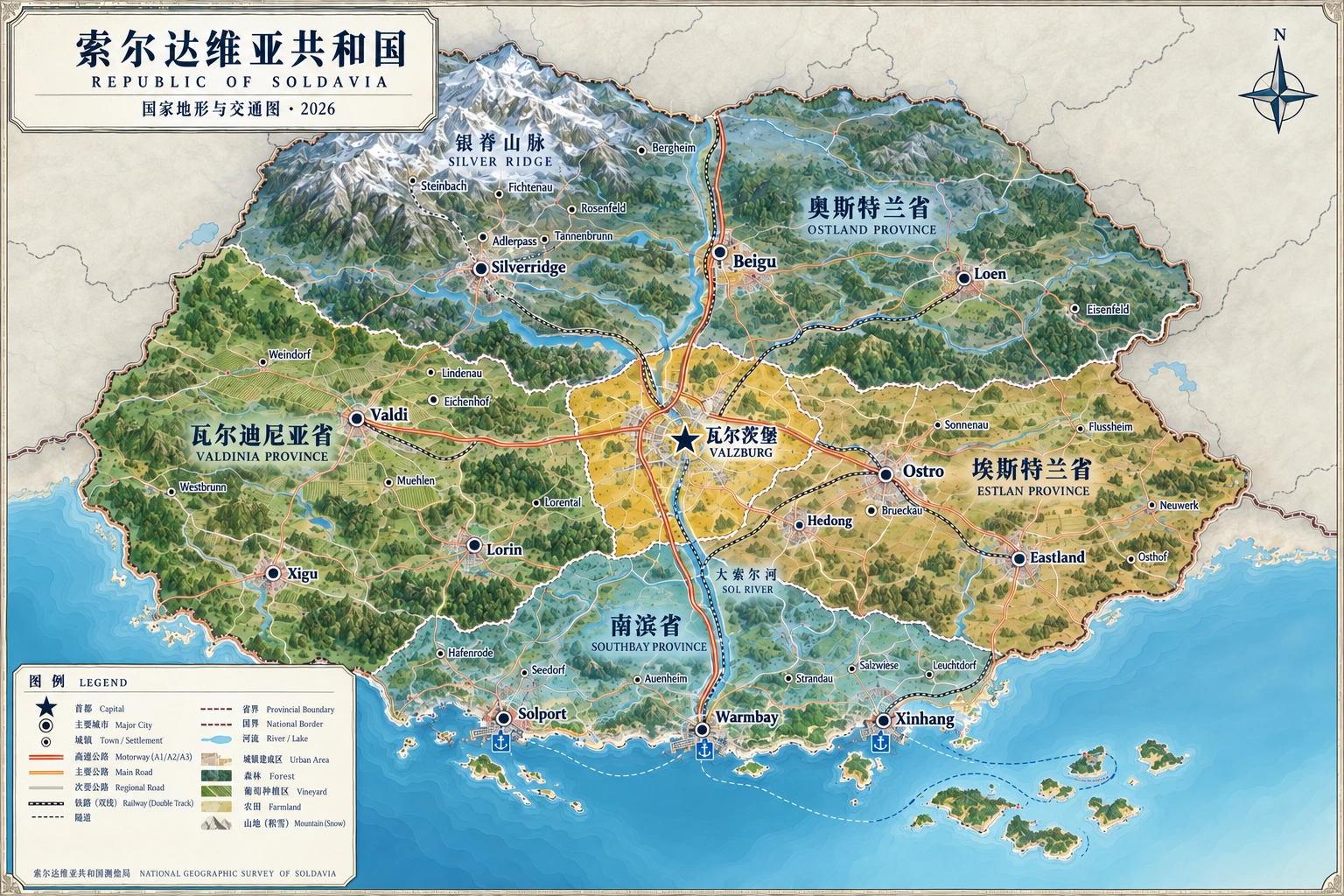
Connected towns, from mountains to sea.
Explore the national terrain and transport map, Valzburg street map and city aerial view. Zoom into roads and search 24 new towns.
Explore the National & City Atlas →Provinces
- Valzburg Capital TerritoryGreat Sol River · Central plains
- Osterland ProvinceSilver Ridge · River headwaters
- Esterland ProvinceEastern hills · Industrial corridor
- Valdinia ProvinceWestern uplands · Vineyards
- South Coast ProvinceWarm Bay coast · Estuary plains
Special Districts
- Silver Ridge Ecological Special DistrictMountain conservation area
- Warm Bay Islands Special DistrictIsland autonomy and free port
Valzburg Capital Territory
- Administrative seat
- Valzburg
- Administrative code
- SLD-00
- Population
- 1.56 million
- Area
- 8,200 km²
Three northern cities
Three western cities
Three eastern cities
Three southern cities
Special districts overlap existing territories; their populations and areas remain included in regional totals. This is a schematic map.→ Return to Administrative Profiles
- Northern Mountains: Silver Ridge spans the northern border, mostly 1,500–2,600 meters high, forming the main water source and skiing region.
- Central Plains: the Great Sol's fertile alluvial plains contain much of the population and farmland, including the capital, Valzburg.
- Southern Coast: Warm Bay's winding coast has natural harbors and tidal flats, supporting shipping and fishing.
Rivers & Waterways
The Great Sol is the longest river. It winds south from the mountains into Warm Bay in South Coast Province, forming a major transport artery. Tributaries irrigate the Golden Grain Belt, and mountain terrain provides abundant hydropower.
Climate
The country transitions from temperate continental to mild maritime climate, with distinct seasons and moderate rainfall. Northern mountains have long snowy winters and lower temperatures, while the southern coast has mild winters and cool summers.
| Region | Climate type | Characteristics |
|---|---|---|
| Northern Mountains | Alpine / humid subarctic | Long snowy winters, cool summers and mountain precipitation |
| Central Plains | Temperate continental | Distinct seasons, larger day–night temperature differences and moderate rain |
| Southern Coast | Mild maritime | Mild winters, cool summers, year-round moisture and sea breezes |
Natural Resources
Offshore wind and tides support the southern coast, while northern mountains provide hydropower and rare metals. Central plains grow wheat, maize and grapes. Forests cover about 32%, supporting paper production, ecotourism and carbon storage.